

Do you like mountains? Landscapes? New destinations? The PeakFinder AR app is every traveler’s/explorer’s/geography-enthusiast’s dream! PeakFinder AR (augmented reality) uses AR technology to show the names of all the mountains and peaks with a 360° panorama display around you. You just download the map and agree to let it use your location when using the app, and voila. Just like that, you know every peak!
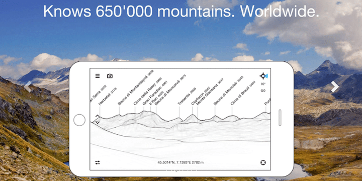
PeakFinder can show you the name of what you’ve been staring at for minutes or years. It knows more than 650,000 peaks, from Mount Everest to the little hill around the corner. It’s highly rated on both the Android and iOS, and though it’s $4.99 to download, if you ask me it’s well worth the money to make every new destination more interesting.
The best part? The app is advertising-free and works completely offline around the world. It was the winner of several awards—like “Best of the App Store” and “App of the Week”—and it has been highly recommended by NationalGeographic.com. I’m not surprised!
From the App Store description, here are the features:
- Overlays the camera image with the panorama drawing.
- Realtime rendering of the surrounding landscapes in a range of 300km/200mil.
- Digital telescope to select less prominent peaks.
- “Show me”-function for visible peaks.
- Selection of the viewpoint by GPS, the peak directory or an (online) map.
- Can fly like a bird from peak to peak and vertically upwards.
- Shows the solar and lunar orbit with rise and set times.
- Uses compass and motion sensors.
- Daily updates of the peak directory.
- Does not collect any data. Your data is yours.
- Does not contain any recurring costs. You pay only once.
More nature
- How to Find the Perfect Place to Camp in the U.S.
- Travel Book of the Week: “Great Hiking Trails of the World” by Karen Berger
- The Adventure Watch Every Outdoor Enthusiast Will Love